Thursday, May 19, 2011

Yonge & Dundas


I would like to lament on two facts before I drop some knowledge.

#1 That every time I try to take before and after photos downtown it is raining! What gives? Here I am balancing my umbrella, my reference images and my camera. Plus let it be summer soon so I can shoot with some sun!

#2 Apparently people (in cars) have issues when I stand for long periods of time in the middle of the road during rush hour. LOL Must be members of the Rob Ford Nation. I’m creating art here people!

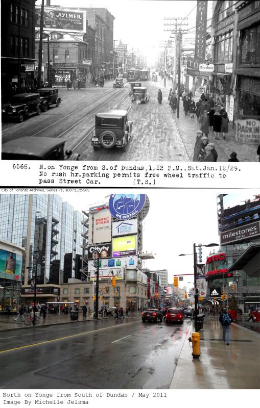
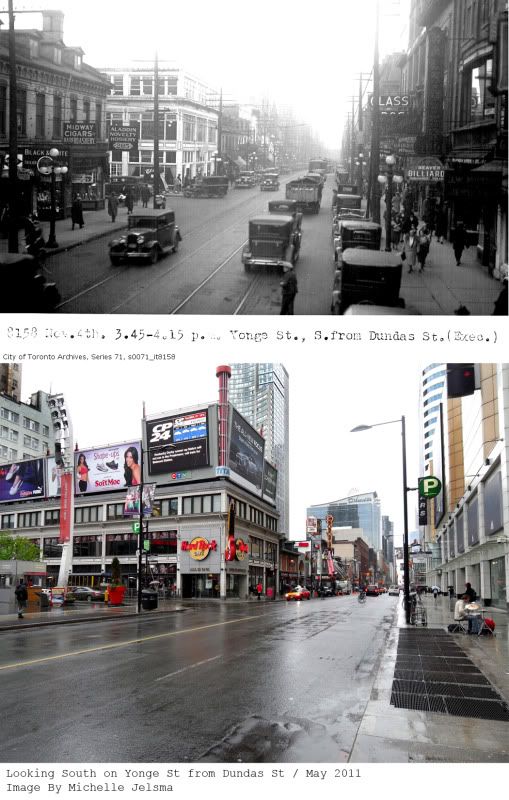
I dedicate this entry to the hard working employees at H&M Eaton Centre. Just when you thought you could escape work for the moment, I thought that it might be interesting to see what this familiar location in Toronto looked like in the roaring twenties. For those of you who are not familiar with Toronto this is the intersection of Dundas and Yonge. It has become the city’s Time square if you will but it wasn’t always like that. Dundas Street is named as such because it used to be the route that travelers would take to get to the town of Dundas in south western Ontario, much like Kingston road would take travelers to Kingston, Ontario. Yonge Street is Toronto’s “Main Street” if you will as it divides the city (East/ West) and is famous for being one of the longest roads in the world. Yonge has been a aboriginal trail and since John Simcoe Graves

I love reading the business signs on the old buildings, for instance the location which is now a “Forever 21” used to be the “United Cigar Store”. Also we can see a Laura Secord location, a Dentist office and a hair salon. The best two have got to be the “Beaver Billiards” and an “Aladdin’s Novelty Hosiery”. When looking at the before and after images I find it interesting to see what structures are located on the sites where the Eaton Centre and Dundas Square are currently located. To be honest my memory of what was located on the North and South East corner are a little vague. Funny how it has only been a couple years and things are starting to erase itself from my memory.

Friday, May 13, 2011

Don Mills


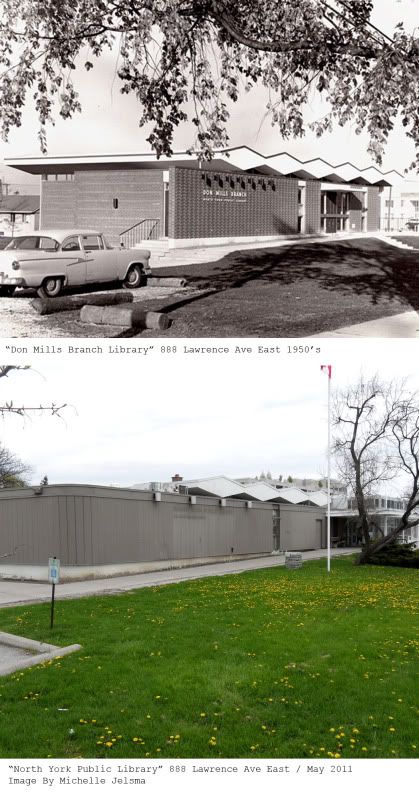
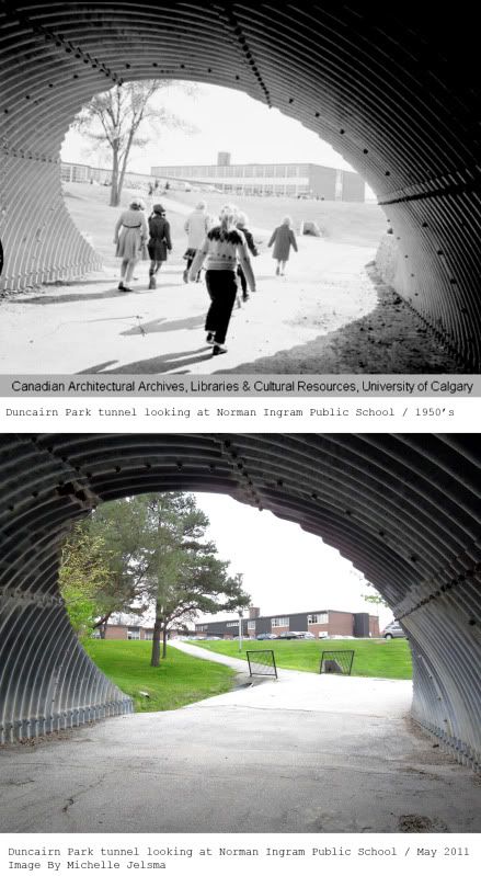
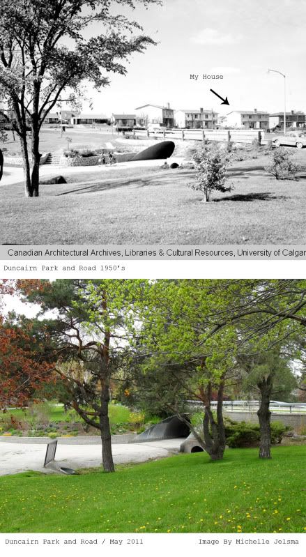
Unfortunately I was unable to get downtown this week to take pictures of Toronto landmarks. I live in Don Mills which is a suburb of Toronto and also happens to be Canada’s first planned community. I got really excited when I found old pictures of where I grew up; it was almost my very own “Back to the Future” flash back moment. I thought I would share them with you.

Pre WW2 my neighbourhood was isolated farm land, owned by the Milne family. You can find their old abandoned farm house in Charles Sauriol Park and their grave in Edwards Gardens. It was EP Taylor who bought up this land and turned it into iconic suburbia. Don Mills Rd and Lawrence Ave East is the centre of the community with the Donway circling it. Each quadrant was built to have a Church, a School and a network of park path systems so children didn’t have to walk across major roads. At the centre was the Don Mills mall and community centre and along the periphery of the community were the industrial buildings. I live in the North West quadrant which had the Library and Norman Ingram Public school.

The thing I love about Don Mills is that a majority of the remaining buildings have a Bauhaus/Googie style to them (Think iconic television 1950’s style with a twist of the Jetson’s). You can see this in the diamond pattern roof on the library. The inside of the library nowadays looks pretty good as they have made a few renovations; unfortunately the exterior has much to be desired because the original architecture is so hidden. The image with the tunnel is cute because I remember screaming my head off going through it, so I can picture those kids doing the same. I was interested and curious to also see how they eliminated so many windows in my elementary school. I guess they are trying to save money with heating. My favourite picture is the one where my house is depicted in a barren landscape and how much the foliage has taken over. It gives me hope when I look at all the planned communities springing up that they too could develop into something more.

Thursday, May 5, 2011

Royal Ontario Museum


The three things I love the most about the Royal Ontario Museum.

Bat Cave, the mummy and the dinosaur skeletons!

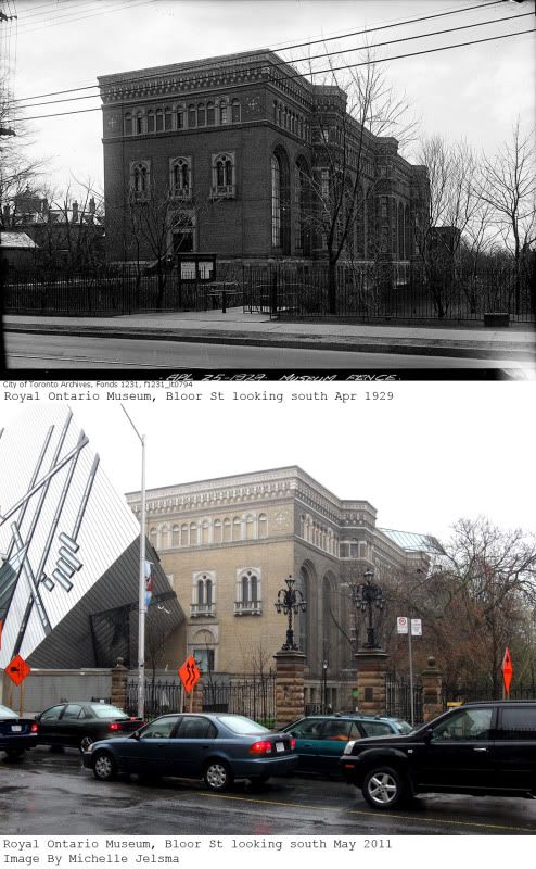
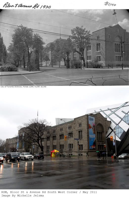
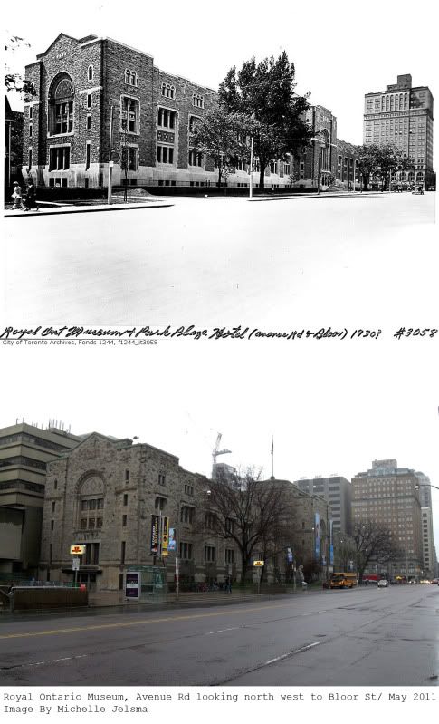
The ROM is located on at the corner of Avenue Road and Bloor Street west. I was interested to learn that Bloor Street was named after Joseph Bloore, who happened to found the village of Yorkville. He owned a tavern and was a brewer, so I imagine he was quite popular. It was considered the dividing line between York (Toronto) and Yorkville and it is still today considered the point where downtown becomes midtown.

The land where the Museum is situated used to belong to William Dummer Powell who lived there during the early 1800’s. He was a lawyer , a judge and if you haven’t already guessed was in Toronto’s Family Compact (See Grange entry). Eventually Bishop John Strachan bought 50 acres of land from Powell and other friends near the northern heavily forested end of the city in around 1827-29 to create a collage. Eventually the many collages because what is known as the University of Toronto. The ROM was located here because of its affiliations with the college and I imagine was meant as a learning aid for many of the students.

I discovered that it is actually the western section of the building, next to philosophers walk, that is original structure. This building was conceived of in 1912 and completed in 1914 (See first image series). Over the next decades many expansions occurred included the one which is facing east off of Avenue Road (1933), the addition of the sadly abandoned and set for demolition McLaughlin Planetarium (1964) *How are children supposed to learn that Pluto is no longer a planet!?!?!* and the new Michael Lee-Chin Crystal (2007).

You can see that Avenue Road has been widened dramatically and a lot of the trees are no longer there. It is nice to see that the Park Plaza Hotel building is still standing and functioning as a hotel although under another name. Needless to say the Royal Ontario Museum is a great example of how the city has grown and changed over the years. If you haven’t been in a while I would suggest rediscovering this landmark.

Friday, April 29, 2011

Palmerston Blvd & Harbord St


This entry is by request of my sister Amanda who loves Palmerston Blvd. She often goes to Sneaky Dee’s and is enchanted by the old homes and the gated entrance. I managed to find two interesting images from the intersection of Palmerston Blvd and Harbord Street.

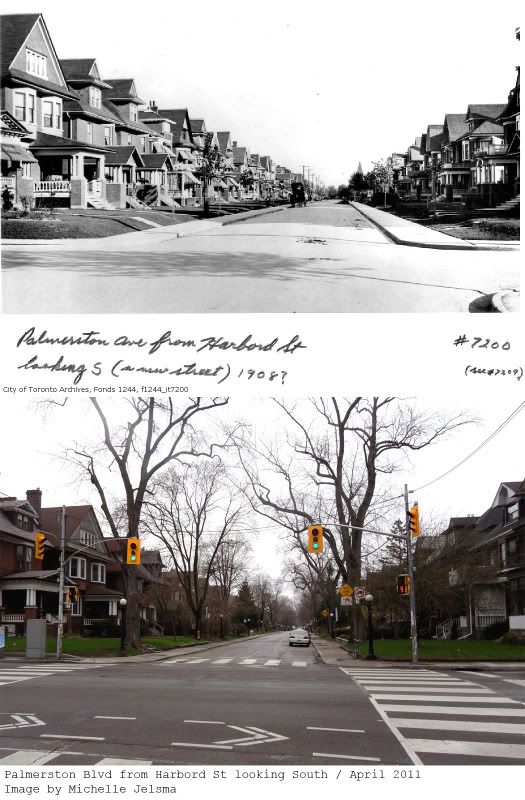
What once was called Muter Street after Lt-Col Robert Muter of the Royal Canadian Rifle Regiment; it was changed to Palmerston (Ave & Blvd) after the Prime Minister Lord Palmerston of the United Kingdom. Known as one of the more upscale residential streets in the past, most of the houses were built between 1903 and 1910. Many of Toronto’s well to-do lived on this street including past mayors of the city and even the well know Weston Family *cough* President’s Choice *cough*.

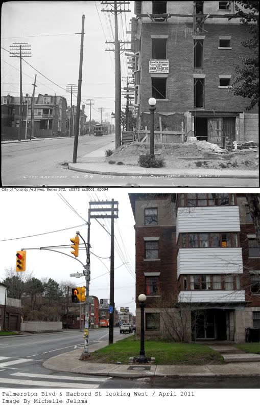
The thing I love most about the first set of images is how tall the trees have gotten over the past hundred years. The second image set is interesting because you get to see how a building has fared from construction to its present state. The building in the 1914 image was meant to house doctor offices and various businesses and now it an apartment building. Many of the houses on this street which were once grand homes for the cities elite have now also been broken up into smaller apartments.

Thursday, April 14, 2011

Masonic Temple

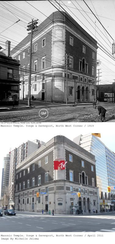
Located on Yonge where Church becomes Davenport is Toronto’s Masonic Temple. It was built in 1917 by William F Sparling & Co. and housed many Masonic orders for years including the Knights Templar. It became a concert venue in the 1960’s and many popular bands held concerts here, from Led Zeppelin to David Bowie. Eventually it was bought by CTV and became a broadcasting location. I remember it as being the location where they would host the Comedy Now shows. It has since been purchased by MTV Canada as can be seen from the sign on the side of the building. Because of its lucky address (888 Yonge) there was talk about transforming it into a condo, but that plan has been cancelled as the location became a heritage site. Did you know Davenport Road stands on what used to be an old carry trail used by the first nations which was located at the bottom of the ridge where Castle Loma is perched on?

On a side note I have to say I love the fact that there has been a Canadian Tire gas station on the corner of Yonge and Church since 1959. I love the retro “Googie” look of the structure. By this time the subway would have been built and passing this location frequently. Hey if anybody knows what stood in this location prior to 1917 I would be interested in learning.

Thursday, April 7, 2011

299 Queen Street West

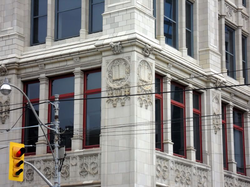
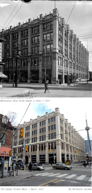
299 Queen Street West located on the South East corner of Queen and John is a Toronto landmark. Much of us know it as the location for Speakers Corner, Much Music, Electric Circus and Breakfast Television (pre Dundas Square move). Did you know the building used to be the headquarters for the Methodist Church of Canada? It was built in 1913 in a Neo-Gothic Terra Cotta facade and it was where the church based their printing house. The Publisher was called The Methodist Book Room and eventually became known as the Ryerson Press. If you check the decal on the side of the building you can see the book design, have you ever noticed that before? Also did you know that John street got its name from the founder of York (Toronto) John Graves Simcoe?

Anyways, the building was bought by CHUM in 1987, it became known as “The CHUM-City Building” and since then has been a broadcast location. It is now owned by CTV and a few of the shows have been moved to new City-TV location in Dundas Square. When I think of this building I will always remember plastering my face to the glass to catch a glimpse of Rick the Temp or Strombo. I got to see bands perform there and met members from Lord of the Rings (squee). I remember the girls dancing in the windows for Electric Circus and rambling like an idiot on Speakers Corner. I am glad that this beautiful building has survived so much change and I hope it will continue to do so.

Friday, April 1, 2011

The Coffin Block: Front/ Wellington/Church

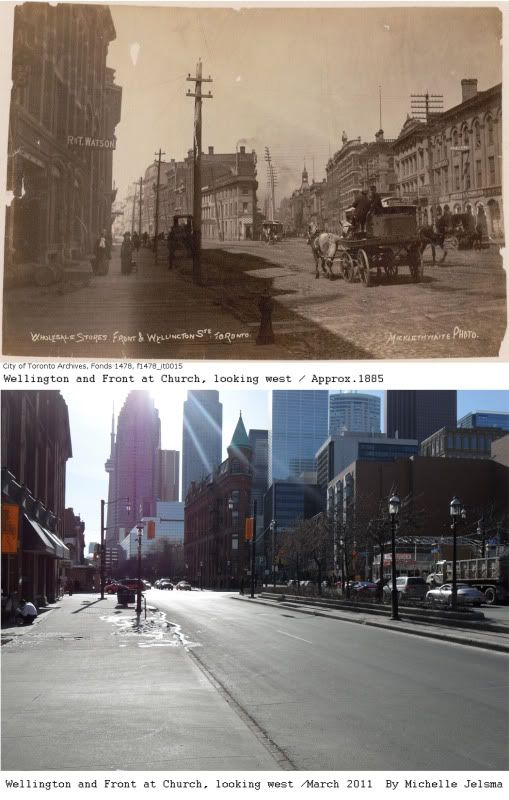
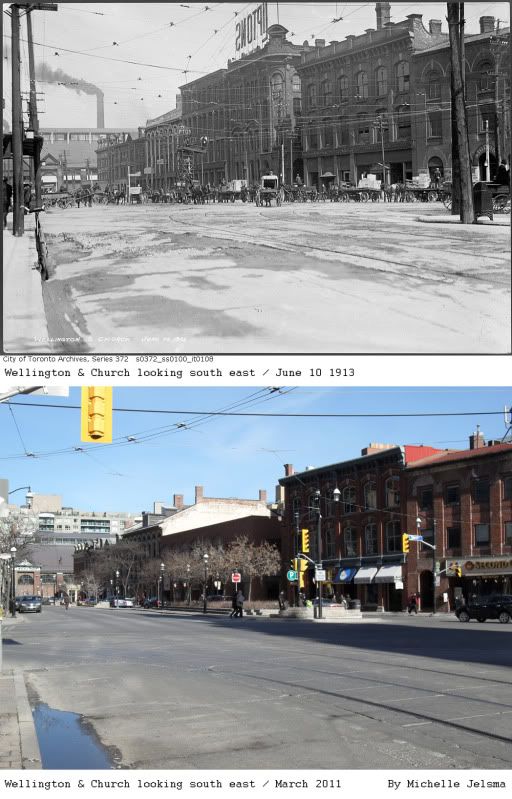
Back when the city of York was nothing but wooden structures and muddy roads, where land met Lake Ontario we have the site for our next feature located. Front and Wellington (which used to be known as Market Street) at Church used to be the outskirts of the city. Since this location was so close to the water it would often get flooded in the spring and the fall. The city built a retaining wall on the south side of front which was 20 ft above the water level to help with this issue. This is why the streets south of Front all have a steep decline at this point. Eventually the city had need for more land and over the decades they would use garbage to extend the waterfront to its present location. Cooper’s Warf was located at the bottom of Church Street. Ships would be arriving with merchandise, produce and other items. The buildings on the south side of the street started out as wooden structures and then became more substantial as a need for storage yards and factories were needed. The skies would be blackened and filled with the stench of coal burning. This can be seen at its pinnacle in the second image taken in 1913. Here we have Liptons factory in the forefront, what looks to be a coal refinery with its smokestack behind the St. Lawrence Market. The Market was built in 1904, it was and still is today a place where Torontonians get a lot of their fresh produce.

During the early 1800’s Travellers would be coming and going and there were a lot of hotels as a result. On the North West corner where the Pizza Pizza now stands was once a farm house built by Peter MacDougall in 1820, which was later remodeled by John Brown in 1829 into a hotel called Ontario House. Due to the influx of travelers the business prospered so well that they converted the building beside it as well, which was known as the Coffin Block due to its irregular shape. The building became the Wellington Hotel and on the bottom level of this building used to be where people could hire stage coaches for travel throughout Upper Canada.

Apparently the neighborhood resembled that of an old western town. With the multitude of hotels means that prostitution was prevalent. There were wooden sidewalks, stage coaches and to top it all off there were saloons as well. The distillery district is not that far away and in the days before water purification, the local water supply (Lake Ontario) was muddy and contaminated by peoples own filth. The only thing safe to drink was alcohol. Eventually the train tracks were laid south of this intersection on the Esplanade and a lot of the commuting traffic moved to Union Station. The hotels then closed down and this section of the city became more focused on factory work and office buildings. The Ontario House became the new location for The Bank of Toronto in 1860. The Wellington Hotel eventually was purchased by George Gooderham and became the head quarters for his business Gooderham and Worts. His family were experts at making good tasting beer and alcohol and this building provided him with a great view of his workers bringing his beer to the dock yards, trains and saloons in the neighbourhood. This Flatiron building is one of Toronto’s most unique structures due to its irregular designs.

This neighbourhood is now very trendy, filled with Bristow’s, upscale store and condos. Only a few of the original buildings in the neighbourhood are the same. I must note that most of my wonderful information comes to me through articles written by local historian Bruce Bell. He gives walking history tours in the neighbourhood so if you are interested in learning more I suggest attending one.